During the Spanish colonial government, several houses were built for camineros, employees who maintained the island's first roads. Here is their history and what has become of these buildings.
Have you spotted small stone or brick houses along PR-1 or PR-2 while on a road trip?
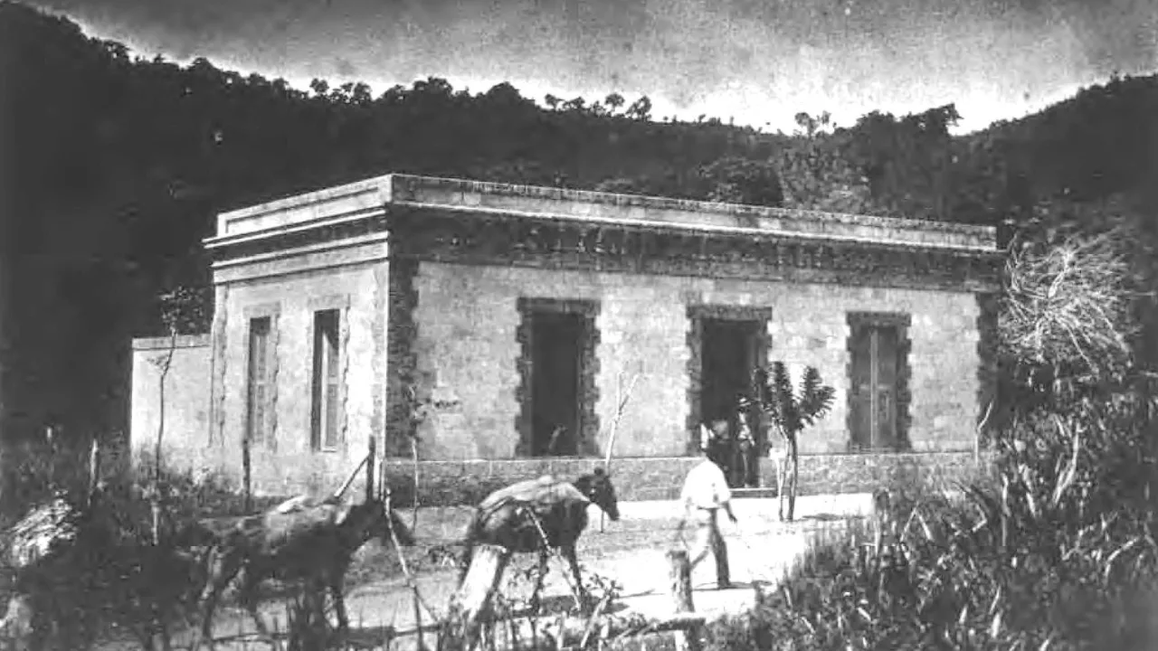
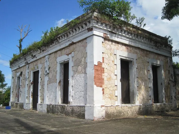
These historic structures on the island's first roads are known as casillas de camineros and were part of the road maintenance and repair infrastructure from the 17th century through the mid-20th century. They belonged to a brigade of operators responsible for road upkeep called camineros.
Here is their history, the reasons these casillas were assigned to them, and what has become of these buildings and the profession.
The camineros and the first roads
Who were they? They were public servants who served as specialized road technicians for the Spanish colonial government. They were part of the first brigades in Spain's road maintenance system in the 17th century.
Camineros were also uniformed employees of the Spanish militia, which made them the first "road police" (Cap 1, Art. 19). They had the authority to stop and fine travelers when necessary. They wore a cream jacket with a leather band and a badge identifying their role.
In the late 19th century, the profession of caminero was introduced in Puerto Rico to maintain the island's first road network, which included PR-1, PR-2, PR-14 (also known as "la Carretera Central"), PR-114 (formerly PR-6) and PR-123.
These first roads, especially "la Carretera Central" (PR-14), served as "a connection for exchange, whether goods or commercial services," urban planner Aptemis Rodríguez told Platea. These routes became trade corridors distinct from the coastal and sea routes used during the Spanish regime.
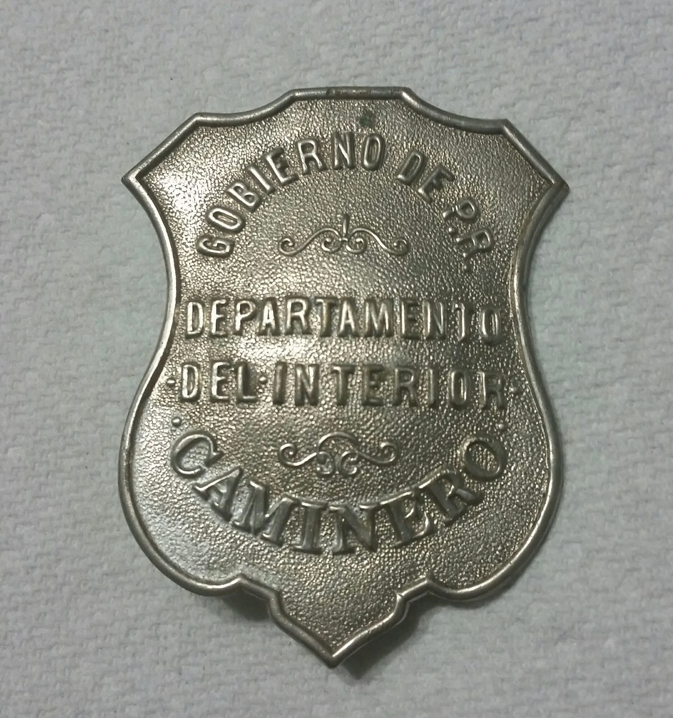
According to the Reglamento para la organización y servicios de los peones camineros y capataces, published Feb. 7, 1905, in the Gaceta de Madrid (Núm. 38), to become a caminero you had to:
Be a man between 20 and 35 years of age
Be a discharged soldier
Be available to work every day of the year, including holidays
Know how to read, write and count
How did the work function? Each caminero was assigned a road segment of 3 to 4 kilometers (approximately 2 to 2.5 miles) that he was responsible for walking daily to maintain and repair the public road. He also provided roadside assistance to travelers.
The caminero casillas
What were they? The casillas were homes that the Spanish colonial government provided to camineros and their families in exchange for their services. They were located two leagues (6 miles) apart along the main roads.
That way, each caminero, typically a lead worker and an apprentice, could set out from the casilla in different directions to carry out their daily duties.
What were the benefits? For Andy Rivera, president and founder of the Puerto Rico Historic Building Drawings Society (PRHBDS), the housing benefit for a caminero was highly sought after at the time, given the widespread poverty across the island and the fact that most houses were built of wood.
"Saying that you had your own masonry house, a construction method using stones or bricks bound with a mixture of cement, water and sand, when more than 70% (of houses) were made of wood" was significant, he told Platea, speaking about the privileged position of road workers of the era.
📍PR-1: Ponce, Juana Díaz, Santa Isabel, Salinas, Aibonito, Cayey, Cidra, Caguas, Aguas Buenas, Guaynabo, San Juan
📍PR-2: From Mayagüez to Añasco, and from Bayamón to Toa Baja
📍PR-14 ("Carretera Central"): San Juan, Río Piedras, Caguas, Cayey, Aibonito, Coamo, Juana Díaz and Ponce.
📍PR-123: Ponce to Adjuntas
📍PR-114 (formerly PR-6): Mayagüez to San Germán
Details about the historic structures
Architectural style: These houses were simple, with a "neoclassical military style," because they reflected a standardized model used for various military structures of the period, explained Jorge Ortiz Colón, a conservation architect and historian with the Historic Built Heritage Program of the Instituto de Cultura Puertorriqueño (ICP).
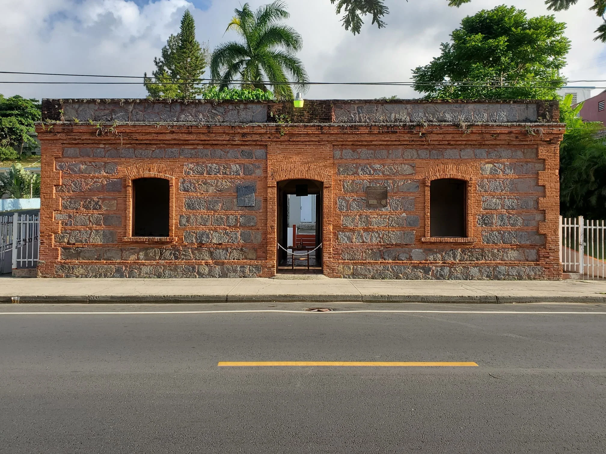
If you have seen the casillas along the island's main roads, you will notice they are rectangular, with a door in the middle and two large windows on either side for better airflow.
Construction materials: Most were built with masonry, stones or bricks, depending on their location and the materials available in the area where they were constructed. They also had wooden elements, such as windows and doors, and were considered sturdy structures that could withstand the changing tropical climate, according to Rivera.
The casillas have few decorative features because of their Spanish "barracks-style," since "there is no attempt to impress with ornaments or anything else," Ortiz Colón told Platea. The most decorative elements were the cornices, moldings that divide the walls from the roofs, which served "to divert water and prevent it from affecting the walls" through erosion.
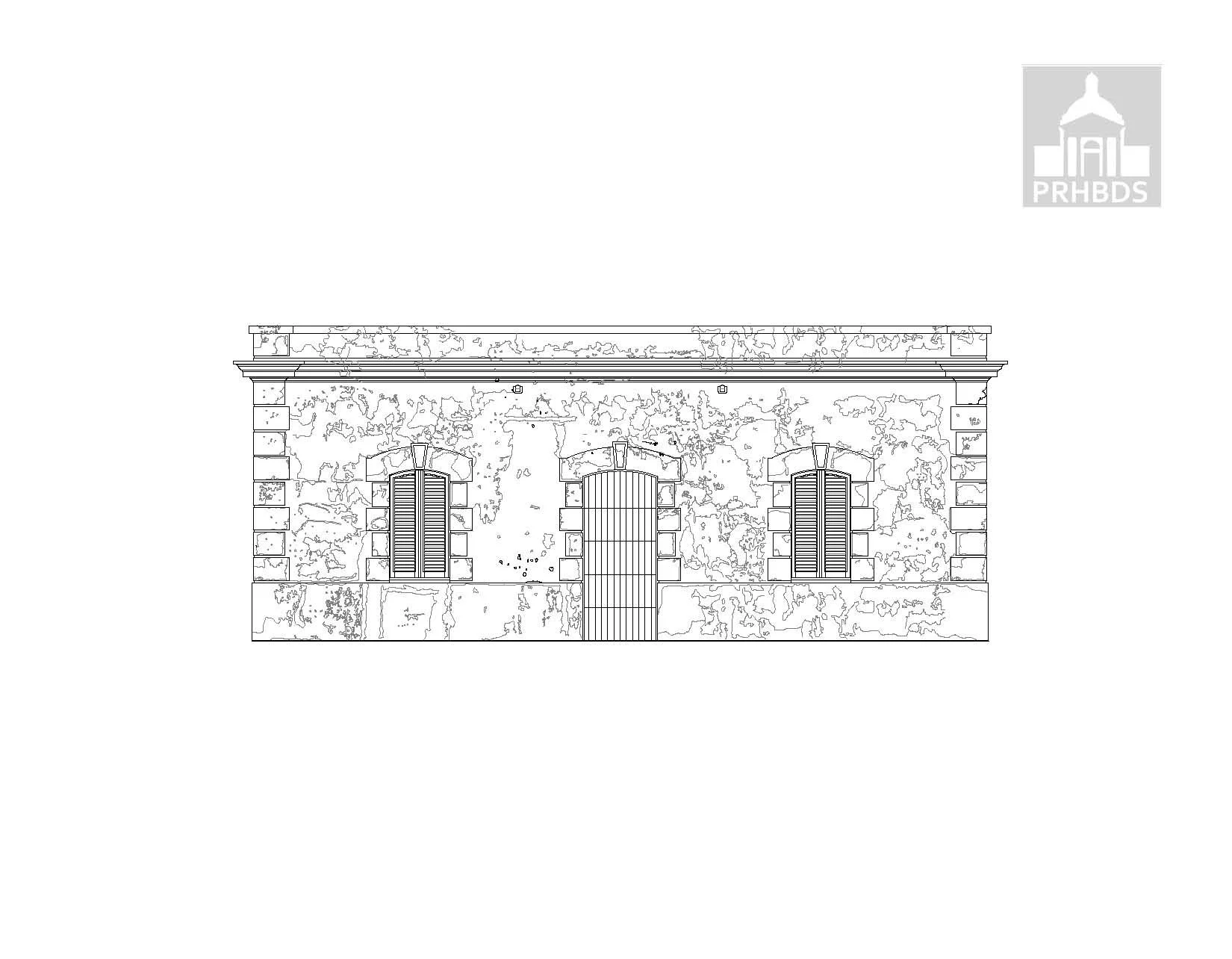
Model of the Casa de Cuerpo de Guardias del Bastión de Santa Elena. The structure is similar to the one used to build the road workers' casillas. (Provided by: Puerto Rico Historic Building Drawings Society, PRHBDS)
Similarities with other colonial structures: "If you compare a military guardhouse, such as the one at El Morro, or a lighthouse like the Faro de Guánica, and compare them with a road worker's casilla, you will note that it is the same house with different details," explained Rivera, of the PRHBDS and an expert on the subject.
In fact, some casillas have very vivid colors, achieved using "the same material," Rivera noted. "There are road workers' casillas whose stone is reddish and you would think it has been painted, but that is the natural stone," he added.
What was the interior of the casillas like?
Over the years, there were different styles of casillas that could house one or two road workers and their families. In most casillas, two road workers lived together with their families.
They measured about 110 square meters (1,200 square feet), Ortiz Colón noted.
Inside, the small houses were divided equally by a central hallway or vestibule that separated each family.
They also had a shared cooking hearth and an outhouse in the yard, as well as access to an aljibe, a type of cistern where water was stored.
"The front door connects to a reception area or vestibule that continues down a hallway to the back door. On either side of this center line are two identical apartments, each with a living and dining room in the front half and two equal bedrooms in the rear half. Each apartment is entered through a door that opens onto the vestibule," explained professor José Mari Mut in his book Nuestras casillas de camineros.
Ortiz Colón confirmed that there was a second, multifamily style of casilla along the route through Coamo, Aibonito, Cayey and Guayama, where each family's apartment was separate.
Architecture student Zairiangely García detailed in her thesis De vestigios a memorias: resignificación del sistema de casillas de peones camineros that this style features "different entrances for each unit while maintaining the four main spaces and eliminating the central vestibule. It consists of a living/dining area, three bedrooms and a kitchen located in an attached volume of lesser height, with a circular opening visible from the main facade."
For single-family casilla styles, the ICP expert noted that these were smaller, measuring about 13 meters (42 feet 8 inches) wide and 8.5 meters (27 feet 10 inches) deep. They can be found in San Juan, Caguas and Guaynabo, where "the first sections of the road (PR-1) to open were built."
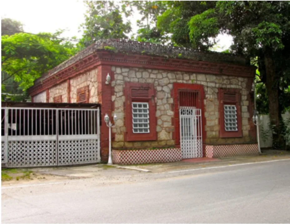
This casilla in Guaynabo is an example of a single-family model. It is currently the private residence of a descendant of a caminero. (Photo: taken from the book Nuestras Casillas de camineros by José Mari Mut)
Protecting the cultural heritage
Despite being called casillas, these homes hold a great deal of history. For that reason, historians and experts on the subject, such as Rivera and Ortiz Colón, are reinforcing the call for their preservation.
What happened to the camineros? With the transition from Spanish rule to annexation by the U.S. government, the caminero system was suspended in 1905 to reduce the cost of maintaining the roads, Rivera explained.
The caminero service was reinstated in 1914, however, due to the rapid deterioration of public roads, but "by 1950, the camineros stopped working with the modernization of the roads," he added.
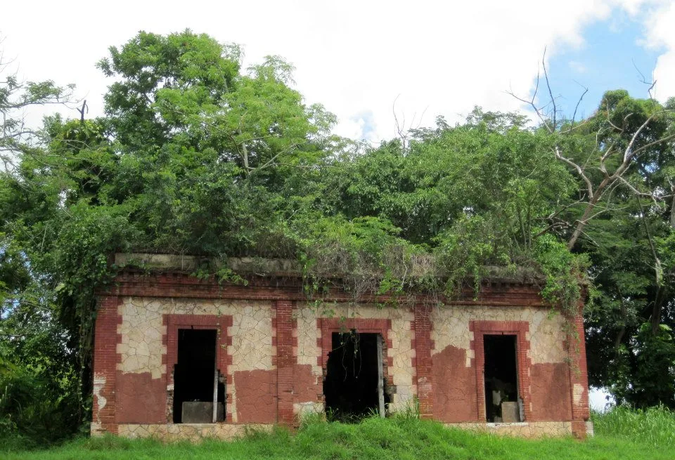
What happened to the casillas? As compensation, many camineros kept their casillas. Some were acquired from the Departamento de Transportación y Obras Públicas (DTOP), the government agency that holds them as temporary housing, by descendants of the camineros. Others have been converted into short-term rentals, such as this historic retreat in Coamo.
Other uses: Some casillas have been used as government offices, schools and learning centers, and community centers, such as the Centro Cultural de Cayey Miguel Meléndez Muñoz, Inc., and some have been modified and expanded to become the Casa de Campo del Gobernador de Puerto Rico, in Jájome, Cayey.
"(It is) the most famous casilla and has nothing to do with the central highway," said Aptemis Rodríguez, an urban planner.
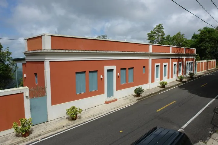
The Casa de Campo del Gobernador de Puerto Rico, in Cayey, is one of the best-maintained and largest casillas, the result of expansions on both sides. (Provided by: Puerto Rico Historic Building Drawings Society, PRHBDS)
A heritage in decline: Most caminero casillas, however, remain in a state of deterioration. In Mari Mut's book, published in 2013, one can count some 14 structures in a state of abandonment. Many have also been purchased for commercial purposes or even demolished to widen roads.
According to experts, no legislation exists to protect these iconic Spanish structures, but there have been rescue and historic preservation projects, such as in the barrio Asomante in Aibonito.
"There are no regulations covering the casillas and, at this time, there is no process regulating what uses are permitted or preventing alterations to them," Rodríguez said. For that reason, registering them as historic monuments is crucial.
Challenges and possible uses for the casillas
The challenge of preservation is "in defining what new uses these structures can have, because, if not, we are condemned to a point where they will no longer exist and the memory of what was once considered one of the greatest engineering works we had in the Americas will be lost, which is the Carretera Central and its casillas," the urban planner said.
With ICP protection and a plan to revive the casillas, the network of casillas and their connection to the roads could give way to the growth of domestic tourism, García argued in her thesis. "I found several points of interest along the network… In addition to passing through many of the historic (urban centers)," the architect noted.
They could also serve as natural museums, rest stops, or cultural centers with photographs from the past.
Although they are not sure what exact use to give them, García and Rodríguez agree on making use of them. "(Giving them) a new use tied to a cultural idea that connects the importance of the urban centers to demonstrate the importance of this road," the urban planner said.
This content was translated with the assistance of Artificial Intelligence (AI).