


Best Hikes in El Yunque National Forest in Puerto Rico
The only tropical forest on U.S. soil, El Yunque’s four distinct forest zones are laced with some of the most accessible hiking trails in the Caribbean.
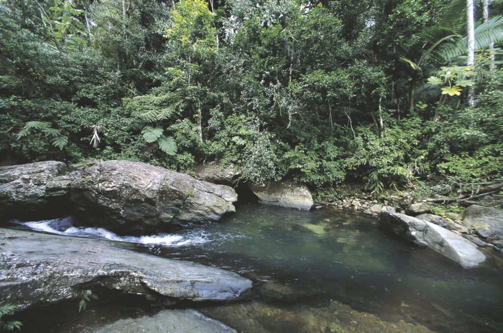
Pretty much unchanged since the Spanish first arrived in Puerto Rico in 1493, El Yunque harbors a spectacular array of flora and fauna. Part of the Sierra de Luquillo on Puerto Rico’s East Coast, the 28,000-acre tropical rainforest has 13 well-maintained hiking trails that attract hikers of all levels. Short paved trails in the north and more primitive dirt paths in the south lead hikers through a magical realm of serrated peaks, cloud-laced mountains, frothy cascades and colossal boulders.
El Portal Visitor Center
On January 20, 2022, El Yunque’s visitor center, El Portal, reopened for the first time since Hurricane María caused extensive damage in 2017. After investments of some $20 million, the state-of-the-art space is fresh from a major overhaul and is well worth allowing an hour or two, at least.
The 40,000-square-foot space (3,716 sq. m) was built using wood from trees felled by the hurricane and is emblematic of Puerto Rico’s spirit of reclamation and renewal. The center mounts a series of interactive exhibits that promote close encounters with resident wildlife, including the endangered Puerto Rican parrot, and reveal ongoing conservation efforts. There are also multimedia displays by local artists, a restaurant and a movie theater. Visits begin with a stirring documentary—produced by Puerto Rican filmmaker María Falcón and narrated by Benicio del Toro—which educates visitors on El Yunque’s distinct ecosystems. A new, accessible trail winds through the surrounding area with interpretative panels that speak to a renewed focus on sustainability, conservation and community engagement—in its previous incarnation, El Portal catered to mass tourism rather than the local community.
Trail system
Most trails are less than a mile long and do not require any scrambling, technical skills or advanced fitness. The epicenter of visitor activity is the north side of the forest, where mostly paved trails create the best hikes in El Yunque for families. The southern recesses are the preserve of more experienced hikers. A challenging 8-hour hike connects the north and south sides of El Yunque.
If hiking is not your thing, you can drive along PR-191 into the mountains where observation areas and picnic spots afford spectacular views.
Flora and fauna
The forest is located high above sea level—El Toro its highest peak at 3,524 feet (107m)— and it comprises four forest zones: some 65 percent is tabonuco forest, which gives way to Palo Colorado forest, sierra palm forest and, at the top, cloud or dwarf forest. El Yunque is home to more than 200 species of tropical trees and an incredible inventory of flora and fauna, including the raucous greenish blue, red-fronted Puerto Rican parrot, once practically extinct but now growing in numbers. Extremely rare sightings include the Puerto Rican boa, which grows to 7 ft (2.1m). Prepare for rain during your visit; the annual rainfall here exceeds 100 billion gallons.
Best Hiking Trails
El Yunque Peak
The park’s signature El Yunque hike is doable for anyone in reasonable shape. It’s well worth the climb for the incredible views from the summit. The 4-km (2.5-mile) paved trail weaves amidst a medley of flora and fauna—gorgeous wildflowers, brightly colored bromeliads, huge ferns, cacophonous birdlife and sonorous tree frogs.
Traversing each of El Yunque’s four forest zones, you’ll slowly ascend through Palo Colorado forest, sierra palms, misty rainforest and cloud forest where dwarf vegetation rarely tops 10 ft (3m). From the summit you can view the snaking coastline of the North Coast and Puerto Rico’s easternmost tip.
If you have the time and energy, it’s worth taking the short out-and-back Los Picachos trail for its beautiful views. The trail intersects with El Yunque trail; take the right fork for Los Picachos, left fork for El Yunque. From here, El Yunque trail is not as well maintained and, at this point, it justifies its official classification as “moderate to challenging.”
With a total elevation gain of 1,500 ft (457m), the 8km (5 mile) round trip takes about four hours. It’s best to hike the trail in the morning to maximize your chance of a clear view from the peak.
Mount Britton Trail
A rewarding short hike, the paved Mount Britton trail is one of the park’s most popular hikes. Accessed from a loop road (PR-9938), located off the upper (southern) end of PR-191, the 1.3km (0.8 mile) out-and-back trail ascends through cloud forest to an altitude of 3,000 ft (914m). The hike’s namesake Mount Britton tower was built in the 1930s by the Conservation Corps. Technically rated an advanced trail, it’s steep in some places and can become very slippery in wet and humid conditions. If the conditions are clear, panoramic views from the tower’s observation deck extend across the Atlantic Ocean, the Caribbean Sea and the eastern coastal plain. Along the trail, keep a lookout for El Yunque’s abundant orchid and fern species which share their habitat with millions of tiny tree frogs, or coquí (pronounced “ko-kee“).
The Mount Britton trail connects to El Yunque trail—one of the island’s highest peaks at over 3,500 ft (1,070m). To reach El Yunque summit, it’s around another mile (about an hour’s hike).
Rio Sabana Trail
Located in the wild and primeval southern recesses of El Yunque, the Rio Sabana trail offers challenging terrain for experienced hikers. Located on PR-191, the 4.6km (2.9 mile) trail begins to the right of the picnic tables. With an elevation gain of some 1,000 ft (304m), it takes around 90 minutes each way to reach the trail’s intersection with the Tradewinds trail, which leads to El Toro Peak. Be mindful that dense, encroaching vegetation and hazardous landslides between the Tradewinds/Rio Sabana junction and El Toro Peak may require alternate routing.
A short hike along the lower section of Rio Sabana trail, provides immediate insight into the park’s primordial aura and staggering biodiversity. This lower section is in much better condition than at the higher elevations. To ascend along the dirt track, you may have to negotiate fallen trees and other detritus resulting from landslides and hurricanes. Regardless of the season, you should prepare for muddy, slippery conditions.
The route climbs through a spectacular profusion of tree, plant and orchid species—flora and fauna that is rarely seen on the busier trails. You’ll pass through sierra palm forest, traverse trickling streams and often clamber over giant boulders. After around one hour, you’ll reach a river crossing with a picnic area. Once you cross the river, the trail becomes densely overgrown and much harder to follow.
Waterfall Hikes
Angelito Trail
El Yunque’s most memorable hikes culminate in beautiful views, picturesque waterfalls and refreshing swimming pools. One of the park’s most family-friendly (and heavily trafficked) trails, Angelito provides great rewards for little effort. Located on PR-988, to reach the trailhead take the first left after entering El Yunque from the Rio Grande entrance. The short and sweet 0.8km (0.5 mile) trail quickly immerses hikers in El Yunque’s magical scenery. A relatively flat, out-and-back, gravel path weaves provides families with a perfect initiation into the wonders of the rainforest. After around 40 minutes, the trail ends with a series of small waterfalls which cascade into an idyllic swimming spot on the Mameyes River. Note that after rain, the path can become muddy and uneven.
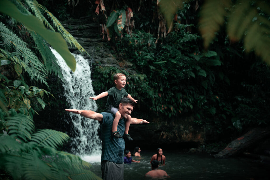
“Angelito is appropriately named as “Angel”— this trail might just be your saving grace if you’re like me and were unable to get a reservation for El Yunque. Close to the trail’s entrance, there’s a tranquil spot where you can bathe in the river. This spot can also be accessed without a reservation.”
– Che Cimadevilla
La Mina Falls
At less than one mile in length, this crowd-pleasing hike in El Yunque provides instant gratification. It’s El Yunque’s most sought after trail—and for good reason—it traces the course of La Mina River. A well-maintained path weaves through beautiful foliage, in every conceivable shade of green, before concluding at the photogenic La Mina waterfall. Hiking time is approximately 40 minutes (each way) and the trail is rated as advanced; the only tricky part is a series of steps which can be physically demanding. The photogenic waterfall cascades over 35 ft (11m) into an enchanting pool where you can either take a dip in the cool water or just relax and enjoy the view.
Make sure you wear sturdy shoes; the rocks to get to the swimming pool are slick. As this trail gets very busy, it’s best to arrive when the park opens at 7:30am before the tour groups descend.
Juan Diego Falls
This short, easy to navigate trail leads to a series of ever more impressive waterfalls. As you drive up the mountain (southwest on PR-191), you’ll find the trail entrance tucked behind a barrier, at approximately KM 9.8. A steep path along the right-hand side of the stream leads to the first of “Lower Juan Diego falls” (around 6.5 ft/2m tall). The larger (20 ft/6m tall) and more impressive waterfall can be seen behind and above and is fronted by a picnic area. On the right-hand side of the falls, a narrow path along a muddy bank leads to “Upper Juan Diego Falls.” At the top, head left to access the 40ft (12m) waterfall which cascades into a lovely swimming pool. This is not technically part of the official trail and so it’s not advised for novice hikers or young children. If you want to access this spot and other unofficial park highlights, it might be worth recruiting the services of a local guide.
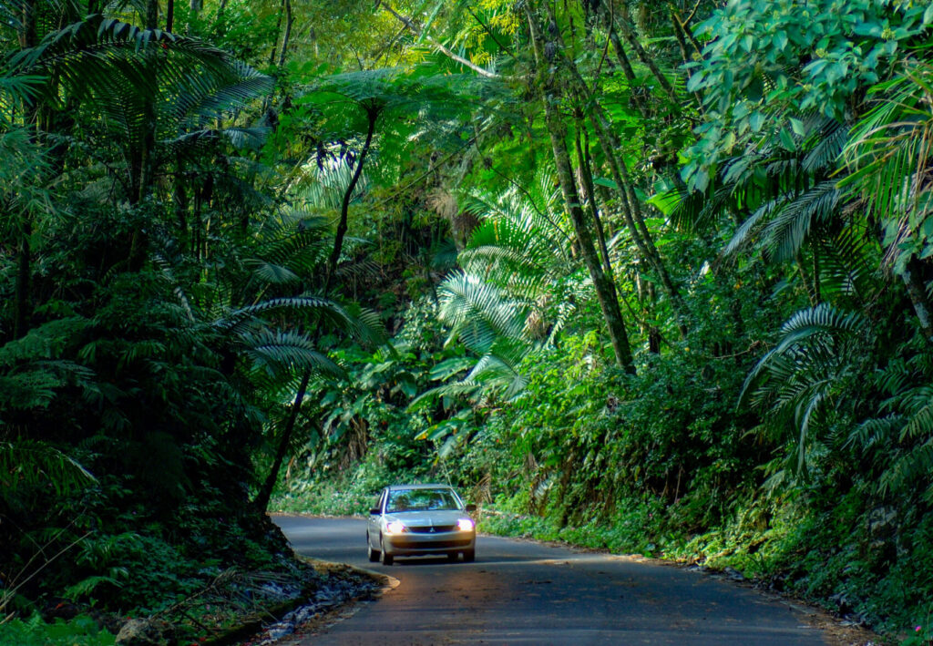
Driving through El Yunque
If you’re not a hiker but would love to experience the rainforest from the comfort of your vehicle, you can follow PR-191 and drive through El Yunque. Even from a car window, you’ll get a good sense of the scale and majesty of the park. From designated observation areas you can have a picnic and take in breathtaking panoramas of the forest and the North and East Coast of the island.
Before you go
Note that El Yunque currently requires reservations. If you know the date you’re visiting, book as early as possible. If you’re a day-of planner log into the reservation system early— spots open up every day at around 6am.
Practical information
Entry: El Yunque is free to enter; a $2 processing fee is applied to credit card bookings. Currently (due to COVID-19), advance reservations are required. Visit the USDA Forest Service for more information on recreational passes and permits.
Getting there: El Yunque is a 45-min drive from San Juan. With a reliable rental vehicle and GPS, tours aren’t necessary.
Getting around: One main road, PR-191 winds through El Yunque providing access to hiking trails and waterfalls.
Suitable for: There are novice to advanced rated hikes, suitable for all ages and abilities.
What to wear: El Yunque experiences some 200 inches of rain each year. Prepare for muddy and slippery hiking conditions; gym shoes and light raincoat recommended.
Use this map to locate all the spots mentioned here:


